


2012年12月11日
新生代(20)−新第三紀(9)−メッシニアン塩分危機

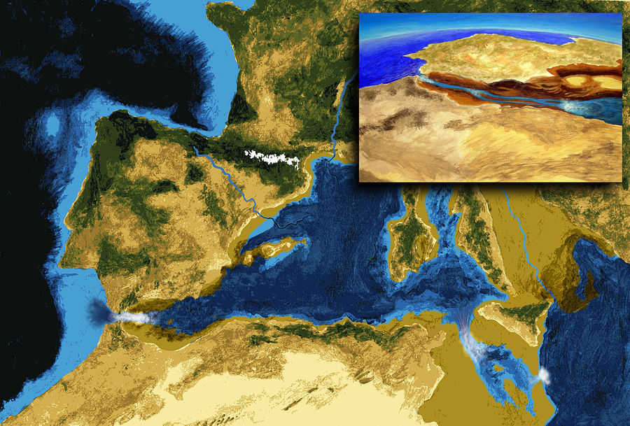
Artistic interpretation of the Mediterranean geography during its evaporative drawdown, after complete disconnection from the Atlantic. The rivers carved deep gorges in the exposed continental margins; The concentration of salt in the remaining water bodies lead to rapid precipitation. The inset evokes the transit of mammals (e.g., camels and mice) from Africa to Iberia across the exposed Gibraltar Strait.
大西洋から完全に遮断された後の蒸発乾燥した期間における地中海地理の想像図。 河川は露出した大陸棚に深い峡谷を刻み、塩分の濃縮は残留水域に急速な沈殿をもたらした。挿入図は、露出したジブラルタル海峡を通ってアフリカからイベリアまでの哺乳動物(例えば、ラクダやネズミ)の通過を再現している。
(旧暦10月28日)
え〜っ!地中海って、海水が蒸発して干上がってしまったことがあったんだってえ〜・・・?!
な、なんで〜?
それは、カリフォルニア大学サンタバーバラ校の人類学の名誉教授、Brian Murray Fagan(1936〜)編著『 THE CONMPLETE ICE AGE』によれば、
およそ600万年前の新生代中新世末期のメッシニア期(Messinian、724万6千年前〜533万2千年前)に地殻変動が進行してジブラルタル海峡が閉鎖され、地中海が一時的に太平洋から分離された時期があった。
この間に地中海は何度か干上がって、厚さ最大3キロメートルもの岩塩(蒸発岩)堆積層が形成され、世界中の海水に溶解していた塩分の6%近くが岩塩となって沈殿し、地球規模の気候大変動をもたらした。その後、約550万年前には、地中海は完全に孤立して塩の砂漠となってしまった。
と云うものです。
新生代中新世末期のメッシニア期(Messinian、724万6千年前〜533万2千年前)と呼ばれる階層の時代区分に地中海の海水が干上がった事象は20世紀後半に解明され、これをメッシニアン塩分危機(Messinian salinity crisis)と呼んでいます。
以下、ウィキペディアによる解説を参照してみましょう。
Messinian salinity crisis
The Messinian Salinity Crisis (MSC), also referred to as the Messinian Event, and in its latest stage as the Lago Mare event, was a geological event during which the Mediterranean Sea went into a cycle of partly or nearly complete desiccation throughout the latter part of the Messinian age of the Miocene epoch, from 5.96 to 5.33 Ma (million years ago). It ended with the so-called Zanclean flood, when the Atlantic reclaimed the basin.
メッシニアン塩分危機
メッシニアン事象、そしてその最新の段階ではラーゴ海事象と呼ばれるメッシニアン塩分危機(MSC)は、地中海が596万年前から533万年前の中新世メッシニア期の後半に、一部もしくはほぼ全域が乾燥する循環周期に移行したという地質学的な出来事であった。そしてその出来事は、いわゆるザンクレアン洪水で終結し、その時大西洋は地中海を取り戻した。
Sediment samples from below the deep seafloor of the Mediterranean Sea, which include evaporite minerals, soils, and fossil plants, show that, about 5.96 million years ago in the late Miocene period, the precursor of the Strait of Gibraltar closed tight and the Mediterranean Sea, for the first time and then repeatedly, partially desiccated.
蒸発岩鉱物、土壌、植物化石を含む地中海の深い海底の下からの堆積物標本は、中新世後期およそ596万年前、ジブラルタル海峡の前身が固く閉じて、地中海が初めて、そしてそれからは繰り返し、部分的に乾燥したことを示している。
5.6 Ma ago the strait closed for the last time and, because of the generally dry climate conditions, within a millennium the Mediterranean basin nearly completely desiccated, evaporating into a deep dry basin bottoming at some places 3 to 5 km (1.9 to 3.1 mi) below the world ocean level, with a few hypersaline Dead Sea–like pockets.
560万年前、一般の乾燥気候状態のために海峡は最終的に閉じ、死海の様な窪地のわずかな過塩水とともに、場所によっては海水面より3〜5キロメートル下の深く乾燥した盆地底部まで蒸発しながら、1000年以内で地中海盆地は完全に近い状態まで干上がった。
Around 5.5 Ma, less dry climatic conditions allowed the basin to resume receiving more fresh water from rivers, with pockets of Caspian-like brackish waters getting progressively less hyper-saline, until the final reopening of the Strait of Gibraltar 5.33 Ma with the Zanclean flooding.
約550万年前、乾燥の少ない気候条件は地中海盆地に、カスピ海のような窪地に過塩水より薄い汽水を徐々に受け入れながら、河川からのより新鮮な水を受け入れることを再開した。そしてそれは、ザンクレアン洪水に伴う533万年前のジブラルタル海峡の最後の再開まで続いた。
Artistic interpretation of the flooding of the Mediterranean through the Gibraltar Strait.
ジブラルタル海峡を通過する地中海洪水の想像図
Even now the Mediterranean is saltier than the North Atlantic because of its near isolation by the Strait of Gibraltar and its high rate of evaporation. If the Strait of Gibraltar closes again, which is likely to happen in the near geological future (though extremely distantly on a human time scale), the Mediterranean would mostly evaporate in about a thousand years. After that, continued northward movement of Africa may obliterate the Mediterranean.
現在でさえ地中海は、ジブラルタル海峡による隔離に近い状況とその高い蒸発速度により、北大西洋よりも塩分濃度が高い状態にある。
もしジブラルタル海峡が再び閉じるならば、地中海はおよそ千年でほぼ蒸発するであろうことは、人間のタイムスケール上では極めて遠いことではあるが、近い地質学的未来において起こる可能性は高いとされている。その後に、アフリカ大陸の継続的な北への移動が、地中海を消滅させるかもしれない。
Naming and first evidence
The Messinian salt deposits that are outcropping (because they were uplifted by tectonic activity during later episodes) in places like Messina in Sicily, northeast Libya, Italy, and southern Spain have been described since the 19th century and it is then that the salinity crisis theory started to be developed.
Karl Mayer-Eymar (1826〜1907) a Swiss geologist and palaeontologist, studied fossils between gypsum-bearing, brackish and freshwater sediment layers and identified them as having been deposited just before the end of the Miocene Epoch. In 1867, he named the period the Messinian, for the region of Messina. Since then, salt-bearing and gypsum-bearing evaporite layers in many Mediterranean countries have been dated to that period.
命名と最初の証拠
メッシニア期の塩分堆積物は、19世紀以来記述されてきたシシリー島のメッシーナや北東リビア、イタリア、南部スペインのような場所で露頭し、それから塩分危機理論は発展し始めた。
スイスの地質学者・古生物学者、カール・マイヤーアイマー (1826〜1907)は、石膏層と汽水、淡水堆積物層間の化石を調査し、それが中新世末期に堆積したことを識別した。1867年、彼はその時期を、シシリー島のメッシーナにちなんでメッシニアンと命名した。それ以来、多くの地中海諸国における岩塩層と石膏層蒸発岩は、同時期のものとされている。
Confirmation and further evidence
In 1961, seismic surveying of the Mediterranean basin revealed a geological feature some 100–200 m (330–660 ft) below the seafloor. This feature, dubbed the M reflector, closely followed the contours of the present seafloor, proposing that it was laid down evenly and consistently at some point in the past. The origin of this layer was largely interpreted as related to salt deposition. However, different interpretations were proposed for the age of salt and its deposition.
立証と更なる証拠
1961年、地中海海盆の地震波による探査が、海底下およそ100〜200 m の地質学的特徴を明らかにした。 この特徴はM反射面と名付けられ、密接に現在の海底の輪郭に従い、過去におけるいくつかの場所においては均等に一貫して堆積していることを示唆している。この層の由来は、主として塩分蒸着と関係があると解釈された。 しかしながら、異なった解釈が塩の年代とその蒸着に対して提案された。
1957年にはフランスの地質学者ジョーゼス・デニゾー、1967年にはイタリアの地質学者ルジェリから、この層は時代的には中新世後期であったと提唱され、そして同じくルジェリが「メッシニアン塩分危機」(Messinian Salinity Crisis)という言葉を造り出しています。
New and high quality seismic data on the M-reflector were acquired in the Mediterranean Basin in 1970, published by e.g. Auzende et al. (1971)
At the same time, the salt was cored during Leg 13 of the Deep Sea Drilling Program conducted from the Glomar Challenger under the supervision of co-chief scientists William B.F. Ryan and Kenneth J. Hsu. All these deposits were indisputably dated and interpreted for the first time as deep-basin products of the Messinian Salinity Crisis.
M反射面に関する新しく高品質な地震波データは、1970年に地中海海盆で採取され、e.g. Auzendeほか(1971)によって出版された。
同時に、塩は共同チーフ科学者ウィリアム B.F. ライアンとケネス J.シューの管理の下、グローマー・チャレンジャー号から行われた深海掘削計画の行程13の間に切り出された。これらすべての堆積物は、明白に年代が確定されて、初めてメッシニアン塩分危機の深い海盆生成物と分析された。
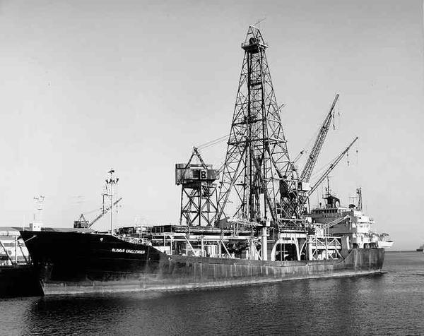
アメリカの海洋掘削船グローマー・チャレンジャー号
The first drilling of the Messinian salt at the deeper parts of the Mediterranean Sea came in the summer of 1970, when geologists aboard the Deep Sea Drilling Program drillship Glomar Challenger brought up drill cores containing arroyo gravels and red and green floodplain silts; and gypsum, anhydrite, rock salt, and various other evaporite minerals that often form from drying of brine or seawater, including in a few places potash, left where the last bitter, mineral-rich waters dried up.
地中海のより深い地域におけるメッシニア期の塩の最初の掘削は、1970年の夏に到来した。その時地質学者たちは、深海掘削計画の掘削船グローマー・チャレンジャー号に乗船して、細流砂利や赤く緑の氾濫原沈泥、そして、塩水または海水を乾燥させることからしばしば生じ、いくつかの場所では炭酸カリウムを含み、最後の苦い、鉱物をたくさん含んだ水が乾燥したところに残される石膏、硬石膏、岩塩、多様な蒸発岩鉱物を含む掘削採取標本を取り出した。
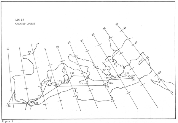
グローマー・チャレンジャー号のLeg 13(行程 13)

Significant accomplishments of Leg 13 included: 行程13に含まれる重要な実績
One drill core contained a wind-blown cross-bedded deposit of deep-sea foraminiferal ooze that had dried into dust and been blown about on the hot dry abyssal plain by sandstorms and ended up in a brine lake interbedded between two layers of halite. These layers alternated with layers containing marine fossils, indicating a succession of drying and flooding periods.
1つの掘削採取標本は、砂塵の中で乾燥し、砂嵐によって暑く乾いた深海平原に吹き散らされ、岩塩の2つの層の間に層をなした塩水湖で終わった深海有孔虫軟泥の風に吹かれた交差層堆積物を含んでいた。これらの堆積層は、海棲化石を含んでる層と乾燥と氾濫の期間の継続を示している層とが交互になっていた。
The massive presence of salt does not require a desiccation of the sea. The main evidence for the evaporative drawdown of the Mediterranean comes from the remains of many (now submerged) canyons that were cut into the sides of the dry Mediterranean basin by rivers flowing down to the abyssal plain. For example, the Nile cut its bed down to several hundred feet below sea level at Aswan (where Ivan S. Chumakov found marine Pliocene foraminifers in 1967), and 2,500 m (8,200 ft) below sea level just north of Cairo.
塩の大規模な存在は、海の乾燥を必要としない。地中海の蒸発による水位低下の主な証拠は、深海平原まで流れ落ちている河川によって、乾燥した地中海盆地の側面に切り込まれた、多くの(現在水没した)峡谷の残骸から得られる。たとえば、ナイル川はアスワン(そこではイヴァン S. チュマコフが1967年に海洋の鮮新世の有孔虫を見つけた)では、その層を海面下数百フィートまで切り下げた。それはちょうどカイロの北では海面下2500mになる。
In many places in the Mediterranean, fossilized cracks have been found where muddy sediment had dried and cracked in the sunlight and drought. In the Western Mediterranean series, the presence of pelagic oozes interbedded within the evaporites proposes that the area was repeatedly flooded and desiccated over the course of 700,000 years.
地中海の多くの場所では、化石化された割れ目が発見されているが、そこでは泥だらけの堆積物が日光と干ばつで乾燥し、割れ目ができた。西地中海の統(年代層序区分)における、蒸発岩を含んだ外洋軟泥の存在は、この地域が70万年の過程の上で繰り返し氾濫し、乾燥したことを示唆している。
このところ、地質学への興味が増大し、地質屋みたいなことになっておりますが、いや〜、地質学は知らないことばかりで、おもしろいですねえ!
次回は、ジブラルタル海峡が開放されて、大西洋の海水が大流入したザンクレアン洪水(Zanclean flood)について調べてみませう。
— 新世紀(11)ーザンクレアン大洪水(2)")
— 新世紀(10)ーザンクレアン大洪水(1)")
-第四紀(9)-破局噴火")
-新第三紀(8)-マンモスの絶滅(2)")
-新第三紀(7)-マンモスの絶滅(1)")
-新第三紀(6)-イエローバンド")
The Messinian salt deposits that are outcropping (because they were uplifted by tectonic activity during later episodes) in places like Messina in Sicily, northeast Libya, Italy, and southern Spain have been described since the 19th century and it is then that the salinity crisis theory started to be developed.
Karl Mayer-Eymar (1826〜1907) a Swiss geologist and palaeontologist, studied fossils between gypsum-bearing, brackish and freshwater sediment layers and identified them as having been deposited just before the end of the Miocene Epoch. In 1867, he named the period the Messinian, for the region of Messina. Since then, salt-bearing and gypsum-bearing evaporite layers in many Mediterranean countries have been dated to that period.
命名と最初の証拠
メッシニア期の塩分堆積物は、19世紀以来記述されてきたシシリー島のメッシーナや北東リビア、イタリア、南部スペインのような場所で露頭し、それから塩分危機理論は発展し始めた。
スイスの地質学者・古生物学者、カール・マイヤーアイマー (1826〜1907)は、石膏層と汽水、淡水堆積物層間の化石を調査し、それが中新世末期に堆積したことを識別した。1867年、彼はその時期を、シシリー島のメッシーナにちなんでメッシニアンと命名した。それ以来、多くの地中海諸国における岩塩層と石膏層蒸発岩は、同時期のものとされている。
Confirmation and further evidence
In 1961, seismic surveying of the Mediterranean basin revealed a geological feature some 100–200 m (330–660 ft) below the seafloor. This feature, dubbed the M reflector, closely followed the contours of the present seafloor, proposing that it was laid down evenly and consistently at some point in the past. The origin of this layer was largely interpreted as related to salt deposition. However, different interpretations were proposed for the age of salt and its deposition.
立証と更なる証拠
1961年、地中海海盆の地震波による探査が、海底下およそ100〜200 m の地質学的特徴を明らかにした。 この特徴はM反射面と名付けられ、密接に現在の海底の輪郭に従い、過去におけるいくつかの場所においては均等に一貫して堆積していることを示唆している。この層の由来は、主として塩分蒸着と関係があると解釈された。 しかしながら、異なった解釈が塩の年代とその蒸着に対して提案された。
1957年にはフランスの地質学者ジョーゼス・デニゾー、1967年にはイタリアの地質学者ルジェリから、この層は時代的には中新世後期であったと提唱され、そして同じくルジェリが「メッシニアン塩分危機」(Messinian Salinity Crisis)という言葉を造り出しています。
New and high quality seismic data on the M-reflector were acquired in the Mediterranean Basin in 1970, published by e.g. Auzende et al. (1971)
At the same time, the salt was cored during Leg 13 of the Deep Sea Drilling Program conducted from the Glomar Challenger under the supervision of co-chief scientists William B.F. Ryan and Kenneth J. Hsu. All these deposits were indisputably dated and interpreted for the first time as deep-basin products of the Messinian Salinity Crisis.
M反射面に関する新しく高品質な地震波データは、1970年に地中海海盆で採取され、e.g. Auzendeほか(1971)によって出版された。
同時に、塩は共同チーフ科学者ウィリアム B.F. ライアンとケネス J.シューの管理の下、グローマー・チャレンジャー号から行われた深海掘削計画の行程13の間に切り出された。これらすべての堆積物は、明白に年代が確定されて、初めてメッシニアン塩分危機の深い海盆生成物と分析された。
アメリカの海洋掘削船グローマー・チャレンジャー号
The first drilling of the Messinian salt at the deeper parts of the Mediterranean Sea came in the summer of 1970, when geologists aboard the Deep Sea Drilling Program drillship Glomar Challenger brought up drill cores containing arroyo gravels and red and green floodplain silts; and gypsum, anhydrite, rock salt, and various other evaporite minerals that often form from drying of brine or seawater, including in a few places potash, left where the last bitter, mineral-rich waters dried up.
地中海のより深い地域におけるメッシニア期の塩の最初の掘削は、1970年の夏に到来した。その時地質学者たちは、深海掘削計画の掘削船グローマー・チャレンジャー号に乗船して、細流砂利や赤く緑の氾濫原沈泥、そして、塩水または海水を乾燥させることからしばしば生じ、いくつかの場所では炭酸カリウムを含み、最後の苦い、鉱物をたくさん含んだ水が乾燥したところに残される石膏、硬石膏、岩塩、多様な蒸発岩鉱物を含む掘削採取標本を取り出した。
グローマー・チャレンジャー号のLeg 13(行程 13)
Significant accomplishments of Leg 13 included: 行程13に含まれる重要な実績
One drill core contained a wind-blown cross-bedded deposit of deep-sea foraminiferal ooze that had dried into dust and been blown about on the hot dry abyssal plain by sandstorms and ended up in a brine lake interbedded between two layers of halite. These layers alternated with layers containing marine fossils, indicating a succession of drying and flooding periods.
1つの掘削採取標本は、砂塵の中で乾燥し、砂嵐によって暑く乾いた深海平原に吹き散らされ、岩塩の2つの層の間に層をなした塩水湖で終わった深海有孔虫軟泥の風に吹かれた交差層堆積物を含んでいた。これらの堆積層は、海棲化石を含んでる層と乾燥と氾濫の期間の継続を示している層とが交互になっていた。
The massive presence of salt does not require a desiccation of the sea. The main evidence for the evaporative drawdown of the Mediterranean comes from the remains of many (now submerged) canyons that were cut into the sides of the dry Mediterranean basin by rivers flowing down to the abyssal plain. For example, the Nile cut its bed down to several hundred feet below sea level at Aswan (where Ivan S. Chumakov found marine Pliocene foraminifers in 1967), and 2,500 m (8,200 ft) below sea level just north of Cairo.
塩の大規模な存在は、海の乾燥を必要としない。地中海の蒸発による水位低下の主な証拠は、深海平原まで流れ落ちている河川によって、乾燥した地中海盆地の側面に切り込まれた、多くの(現在水没した)峡谷の残骸から得られる。たとえば、ナイル川はアスワン(そこではイヴァン S. チュマコフが1967年に海洋の鮮新世の有孔虫を見つけた)では、その層を海面下数百フィートまで切り下げた。それはちょうどカイロの北では海面下2500mになる。
In many places in the Mediterranean, fossilized cracks have been found where muddy sediment had dried and cracked in the sunlight and drought. In the Western Mediterranean series, the presence of pelagic oozes interbedded within the evaporites proposes that the area was repeatedly flooded and desiccated over the course of 700,000 years.
地中海の多くの場所では、化石化された割れ目が発見されているが、そこでは泥だらけの堆積物が日光と干ばつで乾燥し、割れ目ができた。西地中海の統(年代層序区分)における、蒸発岩を含んだ外洋軟泥の存在は、この地域が70万年の過程の上で繰り返し氾濫し、乾燥したことを示唆している。
このところ、地質学への興味が増大し、地質屋みたいなことになっておりますが、いや〜、地質学は知らないことばかりで、おもしろいですねえ!
次回は、ジブラルタル海峡が開放されて、大西洋の海水が大流入したザンクレアン洪水(Zanclean flood)について調べてみませう。
新生代(22)— 新世紀(11)ーザンクレアン大洪水(2)
新生代(21)— 新世紀(10)ーザンクレアン大洪水(1)
新生代(19)-第四紀(9)-破局噴火
新生代(18)-新第三紀(8)-マンモスの絶滅(2)
新生代(17)-新第三紀(7)-マンモスの絶滅(1)
新生代(16)-新第三紀(6)-イエローバンド
新生代(21)— 新世紀(10)ーザンクレアン大洪水(1)
新生代(19)-第四紀(9)-破局噴火
新生代(18)-新第三紀(8)-マンモスの絶滅(2)
新生代(17)-新第三紀(7)-マンモスの絶滅(1)
新生代(16)-新第三紀(6)-イエローバンド
※このブログではブログの持ち主が承認した後、コメントが反映される設定です。